Logo

Online Primary Sources

  • Home
  • All Sources
  • About
  • Newsletter
Filter by
PeriodGeographical areaInstitutionTypeLanguage
  • 20th century (2)
  • 21st century (3)
  • Holocaust (1)
  • Holodomor, 1931-1933 (1)
  • Soviet Union (1)
  • World War II (1)
  • Central Asia (1)
  • Germany (2)
  • Karaganda Region (1)
  • Kazakhstan (3)
  • Kirghizistan (1)
  • Kostanay Region (1)
  • Pavlodar Irtysh Region (1)
  • Poland (1)
  • Russia (1)
  • Semipalatinsk Region (1)
  • Soviet Union (2)
  • Tajikistan (1)
  • Turkmenistan (1)
  • Ukraine (1)
  • Uzbekistan (1)
  • Center for Research on the Ukrainian-Polish-Slovak Borderlands (1)
  • Faculty of Humanities of the Ukrainian Catholic University (1)
  • Oxus Society for Central Asian Affairs (1)
  • Public foundation “Kazakh Association of Germans Renaissance" (1)
  • The “Local History” Project (1)
  • Audio (1)
  • Image (1)
  • Interactive map (3)
  • Links (1)
  • Listing (1)
  • Transcript (1)
  • Video (1)
  • English (2)
  • German (1)
  • Polish (1)
  • Russian (1)

3 sources found in the database

for KazakhstanInteractive map
  • "Zhiva istoriia / Living History" - Oral History & Visual Sources Project, 1900-2022


    Center for Research on the Ukrainian-Polish-Slovak Borderlands

    Faculty of Humanities of the Ukrainian Catholic University

    The “Local History” Project

  • Interactive Archive of Germans in Kazakhstan


    Public foundation “Kazakh Association of Germans Renaissance"

  • Mapping Military Bases in the Five Central Asian Militaries Project


    Oxus Society for Central Asian Affairs

  • «
  • ‹
  • 1
  • ›

Mapping Military Bases in the Five Central Asian Militaries Project


Institution

Oxus Society for Central Asian Affairs

Url

https://oxussociety.org/viz/military-units/

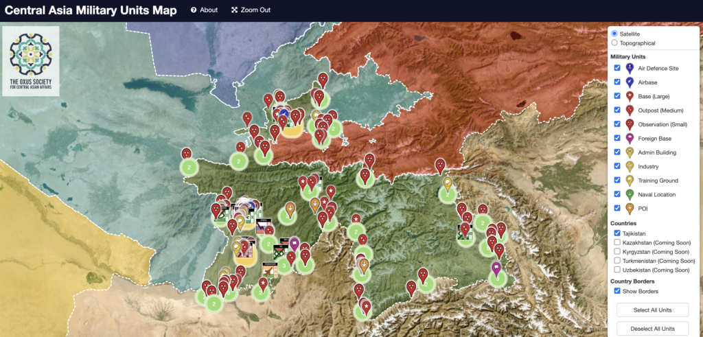
The Central Asia Military Units Map is an interactive tool developed by the Oxus Society for Central Asian Affairs. It provides a comprehensive overview of military installations and units across the five Central Asian countries: Kazakhstan, Kyrgyzstan, Tajikistan, Turkmenistan, and Uzbekistan. This map offers valuable insights into the military landscape of the region, including the types and locations of various military facilities such as bases, airfields, and training grounds.


Type

Interactive map

Geographical area

Central AsiaKazakhstanKirghizistanTajikistanTurkmenistanUzbekistan

Period

21st century

Language

English

Keywords

airfieldsbasescentral-asiageolocationsinstallationsmapsmilitariesmilitary-facilitiestraining-grounds

Published : October 23, 2024

Share this source

Send by email

Share this source by email or save it by sending the data to your mail box.

Newsletter

Receive the latest sources each month

By clicking on the Subscribe button, you confirm that you have read our Data Protection policy.
Logo cnrsLogo ehessLogo cercec

The Online Primary Sources database is curated by
the french Centre for Russian, Caucasian and Central European Studies (CERCEC), a CNRS-EHESS joint research unit.

  • Credits
  • Legal Notice
  • Data Protection